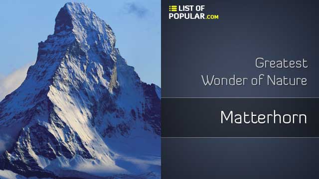
Matterhorn / Cervino
The Matterhorn (Spanish and Italian), Matterhorn (German), Mont Cervin or Le Cervin (French) or Hore or Horu (Walser) is possibly the most famous mountain in the Alps for its spectacular pyramid shape, often reproduced. Its summit, 4478 meters, is the fifth highest peak in the Alps. It is located on the border between Switzerland and Italy. It is above the city of Zermatt, in the canton of Valais, to the northeast, and Breuil-Cervinia, in the Aosta Valley, to the south.
Name
The German name of the mountain, Matterhorn, derives from the words Matte, which means "meadow", and Horn, which means "horn". The migration of the name "meadow" from the bottom of the country to the peak is common in the Alps. The Italian and French names (Matterhorn and Cervin) come from Mons Silvius (or Mons Sylvius) of the Latin word silva, which means forest (again, with the migration of the name from the bottom to the peak). Changing the first letter "s" to "c", who thought that the word referred to a deer (French: cerf and Italian: cervo).
In the work that Sebastian Münster, Cosmography, published in 1543, Matter's name is given to Theodul pass, and this seems to be the origin of the current German name of the mountain. In the topographic map of Münster, this group is marked with the names Augstalberg ("Aosta Mountain") and Mons Silvius. A hypothesis by Josias Simler (De Alpibus Commentarius, 1574) on the etymology of the name Mons Silvius was adopted again by TG Farinetti: "Silvio was probably a Roman leader who traveled with his legions through the land of the Salamis and Sedunas, and perhaps Theodul crossed between these two places. This Silvio could have been the same Servio Galba who César commissioned to open the alpine steps, which since then the merchants got used to crossing with great danger and serious difficulty. Servio Galba, to fulfill the orders of Caesar, passed with his legions from the land of the allobroges (Savoy) to Octoduro (Martigny) in Valais, and raised his camp there. The steps that he was ordered to open from there could only be the Saint Bernard, the Simplon, Theodul and the Moor, therefore it seems likely that the name of Servio, from where Silvio and later Servin, or Cervin, was given in his honor to the famous pyramid". It is not known exactly in what period the new name of Servin, or Cervin, replaced the oldest of which seems to derive.
Height
The Matterhorn is an isolated mountain. Due to its position in the main Alpine watershed and its high altitude, the Matterhorn is exposed to rapid weather changes. In addition, its steep slopes and its isolated location favor the appearance of orographic cloud formations, with the air flowing around and creating vortices, with condensation on the leeward side.
The Matterhorn has two differentiated peaks, both located on a rocky edge 100 meters long: the Swiss summit (4477.5 m) in the east and the Italian summit (4476.4 m) in the west. Their names come from the first ascents, not for geographical reasons, since both are located on the border. In August 1792, the Geneva geologist and explorer Horace Bénédict de Saussure made the first measurement of the height of the Matterhorn, using a 50-foot long chain extended in the Theodul glacier and a sextant. He calculated a height of 4501.7 meters. In 1868, the Italian engineer Felice Giordanomeasured a height of 4505 meters, using a mercury barometer that climbed to the summit. The Dufour map, which was later followed by Italian explorers, gave 4482 meters, or 14,704 feet, as the height of the Swiss summit. A recent measurement (1999) with GPS technology, gave the height of the Matterhorn with an accuracy of one centimeter. The result was 4477.54 masl.
Geography
The Matterhorn has a pyramidal shape with four faces pointing to the four cardinal points: the north and east faces are above, respectively, the Zmutt valley and the Gorner (Gornergrat) ridge in Switzerland, the south face (the only south of the Swiss-Italian border) faces the city of Breuil-Cervinia, and the west face faces the mountain of Dent d'Hérens, which is on horseback on the border. The north and south faces meet at the summit to form a short final edge of east-west orientation.
The faces are enormously steep and only small plates of snow and ice cling to them, with frequent avalanches of snow, which accumulates in the glaciers at the base of each face. The largest is the Zmutt glacier to the west. The northeast Hörnli edge (the central edge seen from Zermatt) is the normal ascent route.
Well-known faces are east and north, visible from Zermatt. The east face is a thousand meters high and, because it is "a long, monotonous slope of lousy rocks", presents a high risk of falling rocks, which makes the ascent dangerous. The north face is 1200 meters high and is one of the most dangerous north faces of the Alps, particularly because of its risk of falling rocks and storms. The south face is 1350 meters high and offers many different routes. The west side, the longest, with 1400 meters, has the least number of ascent routes.
The four main edges that separate the four faces are the main ascent routes. The least technically difficult, the Hörnli (Hörnligrat) ridge, lies between the east and north faces, facing the city of Zermatt. To the west is the edge Zmutt (Zmuttgrat), between the north and west faces. According to Collomb, it is "the classic route to climb the mountain, its longest edge, also the most frayed." The Leon (Crest of the Leone) ridge, which lies between the south and west faces, is the normal Italian route and crosses Pic Tyndall. Collomb comments: "A superb rocky edge, the shortest on the mountain, today covered with many fixed ropes, but a much higher ascent compared to the Hörnli". Finally, the south face is separated from the east by the edge Furggen (Furggengrat), according to Collomb "the hardest of the edges the edge still has an imposing reputation but it is not too difficult in good condition by the indirect end".
The border between Italy and Switzerland is the main alpine divide, separating the basins of the Rhone to the north (Mediterranean Sea) and the Po River to the south (Adriatic Sea). Theodul pass, located between the Matterhorn and the Klein Matterhorn, with 3,300 meters, is the underpass between the Valtournenche and the Mattertal. The passage was used as a crossroads and trade route for the Romans and the Romanized Celts between 100 BC. C. and 400 d. C.
While the Matterhorn is the highlight of the Valtournenche to the south, it is only one of the many four - wheelers of the Mattertal valley to the north, among which are the Weisshorn (4505 m), Dom (4545 m), Lyskamm (4527 m) and the second in height in the Alps: Monte Rosa (4634 m). The entire mountain chain forms a crown of peaks around Zermatt. The region, full of glaciers between the Matterhorn and Monte Rosa, is included in the Federal Inventory of Landscapes and Natural Monuments.
Geology
Apart from the base of the mountain, the Matterhorn is composed of gneiss belonging to the tectonic island Dent Blanche klippe, an isolated part of the Austroalpine nappes, which is above the peninic nappes. The Austroalpine nappes are part of the pullesa plate, a small continent that was torn from Africa before the Alpine orogeny. For this reason the Matterhorn has been popularized as an African mountain. Austroalpine nappes are very common in the eastern Alps.
The Swiss explorer and geologist Horace-Bénédict de Saussure, inspired by the view of the Matterhorn, anticipated the modern theories of geology:
What power had to be needed to break and sweep the missing parts of this pyramid, because we don't see her surrounded by fragment remains, one sees only other peaks - themselves broken to the ground - whose sides, equally torn, indicate an immense mass of rubble, from which we see no trace in the vicinity. Undoubtedly this is that rubble that, in the form of pebbles, shoulders and sand, fills our valleys and our plains.
Training
The formation of the Matterhorn (and the entire Alpine mountain range) began with the breakup of the Pangaea continent 200 million years ago in Laurasia (containing Europe) and Gondwana (containing Africa). The rocks that form the nearby Monte Rosa remained in Laurasia, those that formed the Matterhorn were located in Gondwana, separated by the recently formed Tethys Ocean.
100 million years ago, the extension of the Tethys Ocean stopped and the pullesa plate separated from Gondwana and moved towards the Italian continent. This resulted in the closure of western Tethys by subduction under the pullesa plate (with the Piedmont-Liguria ocean first and the Valais ocean later). The subduction of the oceanic crust leaves remains still visible today at the base of the Matterhorn (accretion prism). The orogeny itself began after the end of ocean subduction when the European continental crust collided with the Pullés continent and resulted in the formation of nappes.
The Matterhorn acquired its characteristic pyramidal form in much more recent times, due to natural erosion during the last million years. At the beginning of the alpine orogeny, the Matterhorn was just a mountain rounded like a hill. Because of its height, it is above the snow line and its slopes are covered with ice, the result of snow accumulation and compaction. During the warmest period of summer, some of the ice melts and seeps into the bedrock. When it freezes again, its expansion (Gelifraction) fractures the rock forming a circus. Four circuses led to the current form of the mountain. Due to their recognizable form, many other similar mountains throughout the world were named or nicknamed the "Matterhorn" of their respective countries or mountain ranges.
Rocks
Most of the base of the mountain is in the Tsaté nappe, a remainder of the Piedmont-Liguria oceanic crust (ophiolites) and its sedimentary rocks. Up to 3400 meters the mountain is composed of successive layers of ophthalites and sedimentary rocks. From 3400 meters to the summit, the rocks are gneisses of the Dent Blanche nappe (austroalpine nappes). They are divided by the Arolla series (below 4200 m) and the Valpelline area (the top). Other mountains in the region (Weisshorn, Zinalrothorn, Dent Blanche, Mont Collon) also belong to the Dent Blanche nappe.
Mountaineering and importance of the mountain
Since the 18th century the Alps have attracted and fascinated generations of explorers and climbers. The Matterhorn remained relatively unknown until 1865, but the successful ascent followed by the tragic accident of the Edward Whymper- guided expedition caused a fever over the mountains surrounding Zermatt.
The construction of the railway linking the town of Zermatt with the city of Visp began in 1888. The first train reached Zermatt on July 18, 1891 and the entire line was electrified in 1930. Since 1930, the town is directly connected to St. Moritz by the panoramic Glacier Express train. However, there is no connection to the town of Breuil-Cervinia on the Italian side. Travelers have to hire mountain guides to cross the 3300 meter Theodul pass glacier, which separates the two locations. The city of Zermatt remains completely car-free and can only be reached by train.
Railways and cable cars have been built to make some of the area's summits more accessible. The Gornergrat train, which reaches a record altitude of 3100 meters, opened in 1898. Areas served by cable car are the Unterrothorn and the Klein Matterhorn (Small Matterhorn) (3883 m, the highest transport system in Europe). The Hörnli hut (3260 m), the starting point of the normal route along the Hörnli ridge, is easily reached from Schwarzsee (2600 m) also frequented by climbers. Both Zermatt and Cervinia function as ski resorts throughout the year and are connected by ski lifts over the Theodul pass. Currently a cable car is planned to go from Testa Grigia to Klein Matterhorn for 2014and join the Swiss and Italian side of the Matterhorn.
The Matterhorn Museum (Zermatt) tells the general history of the region, from mountaineering to tourism. In the museum, which has the shape of a reconstructed mountain town, visitors can relive the first and tragic rise of the Matterhorn and see the objects that belonged to the protagonists.
The Matterhorn Tour can be done by walkers in about ten days. Considered by some to be one of the most beautiful trails in the Alps, it follows many ancient roads that have been linking the Italian and Swiss valleys for centuries. The circuit includes alpine meadows, terraced paths, large forests and glacier crosses. Connect six valleys embracing three different cultures: the German-speaking High Valais, the French-speaking Central Valais and the Italian-speaking Aosta Valley. Good physical conditions were necessary to surround the peak. After reaching Zinal by the Augstbord and Meiden steps, the hiker crosses the Torrent before reaching Arolla. Then you must cross the Col Collon along the road to Prarayer and another to Breuil-Cervinia and back to Zermatt through the Theodul. In total, seven steps between 2,800 and 3,300 meters in a relatively difficult terrain.
History
The Matterhorn was the last of the main mountains of the Alps to be climbed, not so much for its obvious technical difficulty, but also for the fear that inspired the first mountaineers. The first serious attempts began around 1858, especially on the Italian side. Despite appearances, the southern routes are harder and the ropes were repeatedly found with difficult rock passages that made them give up. These first attempts were carried out mainly by hunters from the Valtournenche area, from the Pression and Pelissier families. July 1860, they tried the brothers of Liverpool Alfred, Charles and Sandbach Parker, that arrived to little less than 3700 meters. In August of that same year it was the turn of Vaughan Hawkins and his group, which guided by JJ Bennen reached 3962 meters high.
His first ascent marked the end of the golden age of mountaineering. On July 14, 1865, a rope led by Edward Whymper succeeded. It ended tragically, when four of its members fell and died in the descent. Ascending along the Hörnli edge, Edward Whymper, Charles Hudson, Lord Francis Douglas, Douglas Hadow, Michel Croz reached the summitand Peter Taugwalder father and son. They found considerably easier than expected. However, on the descent Hadow slipped, hitting Croz on the feet and dragging Hudson and Douglas with him. The seven were tied together, and they could all have died, but the rope broke, sending the four mentioned to death on the Matterhorn glacier, 1400 meters below. Later, their bodies were found, except Douglas's, and they were buried in the chapel of Zermatt.
Three days later, on July 17, a rope led by Jean-Antoine Carrel reached the summit of the Italian side. Julio Elliott made the second ascent on the side of Zermatt in 1868 and shortly after Juan Tyndall made a summit. In 1871 Lucy Walker became the first woman to reach the top of the mountain, followed a few weeks later by her rival Meta Brevoort.
William Penhall and his guides made the first (partial) ascent of the west face, the most unknown and hidden Matterhorn, an hour after Mummery's first ascent of the Zmutt ridge on September 3, 1879. It was not until 1962 that amounted west face completely. The ascent was made on August 13 by Renato Daguin and Giovanni Ottin. In January 1978, seven Italian alpine guides managed to ascend in winter by the route that in 1962 opened Daguin and Ottin, not repeated until then. In the descent, an intense storm caught them (accumulated two meters of snow in Breuil-Cervinia and Zermatt), and their achievement was clouded when one of the climbers died during the descent.
The north face was one of the last major problems of the Alps until it was climbed in 1931. To succeed on the north face, you need a good ice climbing technique and ability to find the route. On July 31-August 1, 1931, the brothers Franz and Toni Schmid got the first ascent. They reached the summit at the end of the second day, after a bivouac. Because they had kept their plans secret, their rise was a complete surprise. In addition, the two brothers had traveled by bicycle from Munich and after their successful ascent, pedaled back home. On February 3-4, 1962, Hilti von Allmen and Paul Etter got the first ascent in winter. The first solo ascent was made in five hours by Dieter Marchart on July 22, 1959. Walter Bonatti climbed the "Direct North Face" solo between 18 and 22 February 1965.
After the rise of Bonatti, the best climbers were still worried about the last big problem: the "Zmutt's nose", a ledge on the right side of the north face. In July 1969, Italians Alessandro Gogna and Leo Cerruti tried to solve the problem: it took them four days, although they avoided their steepest part. In July 1981, the Swiss Michel Piola and Pierre-Alain Steiner overcame Zmutt's nose following a direct route, the Piola-Steiner.
The first ascent of the south face was made by E. Benedetti with the guides L. Carrel and M. Bich on October 15, 1931, and the first full ascent of the east face was made by E. Benedetti and G. Mazzotti with the guides L. and L. Carrel, M. Bich and A. Gaspard on September 18-19, 1932.
In August 2013, Kilian Jornet achieved the record speed of ascent and descent of the Matterhorn from the town of Cervinia by the Lion ridge, with a time of 2 hours 52 minutes and 2 seconds.
The Matterhorn is one of the deadliest peaks in the Alps. From 1865 - when it was climbed for the first time - until 1995, 500 climbers have died.
The Matterhorn has become an iconic emblem of the Swiss Alps in particular and the Alps in general. Since the end of the 19th century, when the railroads were built, it has attracted more and more visitors and climbers. Every summer, a large number of mountaineers try to climb it through the Hörnli ridge, the most popular route to the summit.
Ascent routes
Today, all the edges and faces of the Matterhorn and in all seasons have been promoted. Each summer, the mountain guides accompany hundreds of customers along the northeast Hörnli route. According to modern standards, the climb is quite difficult (AD Difficulty), but not too hard for trained mountaineers. There are fixed ropes in parts of the route to help. Even so, several climbers die each year due to a number of factors including inexperience, falling rocks, and massive routes.
The most common route is to take the Schwarzsee cable car in Zermatt to continue to the Hörnli hut (Hörnli-hütte, 3260 m), a large stone building at the base of the Hörnli Edge, where you spend the night. The next day starts very early (at 2-3:30 am), to have time to reach the summit and descend before the clouds and the afternoon storms appear. The Solvay Cabin located at the edge at 4003 m can only be used in case of an emergency.
Other routes on the mountain include the Italian Arista (León), whose degree of difficulty is AD, the Zmutt Edge (difficulty D) and the north face route, one of the six great north faces of the Alps (the degree of difficulty is TD +).
Promotions and deaths
Every season 2500 to 3000 climbers try to conquer the top. On the days of greatest influx they can be up to more than 100 climbers. 70% of climbers choose the easiest and best known route through the Hörnligrat. Each season, around 80 rescue missions must be carried out by helicopter.
Since the first ascent, not a year has passed without a fatal accident at Matterhorn. Each year, eight to ten people die in accidents. Since the first ascent, almost 150 years ago, more than 500 people have died in the Matterhorn, most of them on the Swiss side. In no other mountain in Switzerland do so many climbers die. Between 1981 and 2011, 223 climbers died on the Swiss side, 207 of them as a result of a fall, 5 as a result of the fall of rocks, 3 as a result of a freeze, 3 as a result of a fall on a rope and 3 as Result of a search operation. 21 fallen climbers have not yet been recovered and are still missing.
A dead skier found on the mountain in 2005 was identified in 2018 as the Frenchman Joseph Leonce Le Masne (* 1919), disappeared in 1954.
Records
- The Italian Bruno Brunod needed 2 hours and 12 minutes for the ascent in 1995. The Spanish Kilian Jornet broke this record in 2013 and climbed the mountain from Italy in 1 hour and 56 minutes. Including the descent, Jornet reached a time of 2 hours and 52 minutes.
- On April 22, 2015, the Swiss Dani Arnold broke this record. He achieved the fastest solo ascent of the north face of Matterhorn in 1 hour and 46 minutes.
- Mountain guide Richard Andenmatten (Zermatt) has climbed the Matterhorn more than 850 times.
- Zermatt mountain guide Ulrich Inderbinen climbed the Matterhorn 371 times and more recently at the age of 89.
- In Disneyland there is a roller coaster called Matterhorn Bobsleds, which simulates a bobsled ride through the Matterhorn.
- It was elected finalist for the Seven Natural Wonders of the World.
- In the King of the Hill chapter of the series The Simpsons is referred to.
- In the packaging of Toblerone (Kraft) products appears the Matterhorn mountain peak.
- In the Gran Turismo video game, playable tracks appear where you can see the mountain.
- In 1989 the Matterhorn was the central motif of the logo of the XXXIV Eurovision Song Contest, held that year in the Swiss city of Lausanne.
"Matterhorn / Cervino" is at the 22nd Position in this list.